Following on from my article in the last newsletter (June 2018) highlighting bike infrastructure in Utrecht in the Netherlands, in this newsletter we take a trip to somewhere known for its cycling that is a little closer to home: Cambridge.
Having been born and brought up in the city and now being a frequent visitor there to see family and friends, I have had first hand experience of how riding a bike to get about is a normal and accepted part of life in the city.
In recent years especially, as the city has grown in population and become an increasingly attractive location for companies in the tech and health sectors, cycling has become even more normalised as a means of beating motor vehicle congestion on the roads.
The normalised nature of cycling in the city has in my view historically been in spite of any limited efforts made by City, District or County Councils (which look after different areas within and just outside the city limits) to construct infrastructure or widely promote riding a bike to the population.
University students were among the first in the then town of Cambridge to take up cycling in the late 19th century, followed by townspeople. It is only in more recent times that the local authorities are working together to build infrastructure and promote cycling as a means of getting around, especially as new housing and employment centres are built around the city.
The wider plan for the city region, supported by other key stakeholders such as the University of Cambridge, can be found on the Greater Cambridge Partnership website (https://www.greatercambridge.org.uk).
With a population of around 124,000 in the city itself, Cambridge is a smaller settlement than Reading. Most journeys around the city are relatively short: that from my parents’ house at one of the furthest points within the city limits to the city centre is just under three miles.
Short journeys as we know lend them-selves especially well to cycling, and this combined with motor vehicle congestion and environmental consciousness makes cycling the mode of choice for many people.
Cambridge unlike Reading cannot count on the same provision of local bus services either, further weighting the dice towards cycling around the city. In terms of infrastructure, Cambridge is ahead of Reading.
The following images of segregated cycleways, parking and bikes as part of daily life hopefully demonstrate this, as well as what would be possible in Reading with investment in similar facilities and encouragement and education of the population.
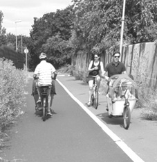
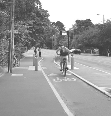
Fig 1: This path, in the Cherry Hinton area in the south east of the city, was once a narrow footpath heavily shaded by trees and with an uneven surface due to their roots.
The path was widened and the trees cut down around two years ago. Despite the encroachment of summer weeds, it still facilitates what is an everyday sight in Cambridge: families travelling around by cargo bike.
The gentleman on the left is travelling towards the city centre, while the people on the right are travelling towards Cherry Hinton.
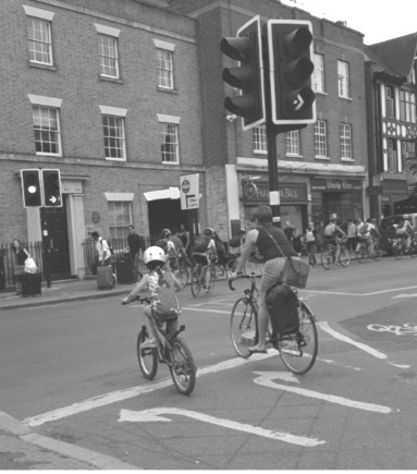
Fig 2: Many parents in Cambridge are also comfortable to let their children ride themselves.
Here a mother and daughter join Regent Street from a dedicated set of traffic lights for bicycles travelling towards the city centre, following a number of other people on bikes.
Behind the camera is Parker’s Piece, a large green space near the city centre traversed by a number of cycle routes to and from the city centre from the south and east of the city.
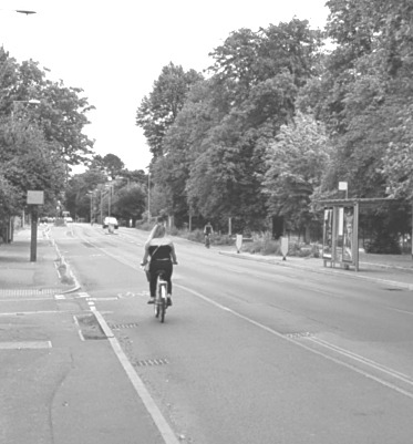
Fig 3: Two key routes between the city centre and key employment and housing sites have recently seen the construction of segregated cycleways, surfaced in red tarmac and slightly raised above the motor vehicle carriageway.
This is one of them, Hills Road, which connects the city centre with the railway station, one of Cambridge’s 6th form colleges, a leisure park and Addenbrooke’s Hospital.
The cycleway has priority over side roads, as can be seen just beyond the woman in the centre of the image who is riding towards Addenbrooke’s.
Bus stops along the road have also been converted to floating island bus stops, allowing the cycle-way to continue around them and overtake buses as needed.
One of these can be seen on the far side of the road.
Fig 4: One of the floating bus stops on Hills Road, with a man riding towards Addenbrooke’s Hospital.
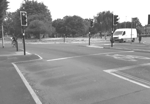
Fig 5: At the roundabout at the entrance to Addenbrooke’s Hospital on Hills Road, the cycleway ends with little indication as to how a person on a bike is meant to navigate it and enter the hospital site (which is to the right of the image, behind the white van), or continue in another direction.
This in my view is one of the “missing links” in Cambridge, where higher quality bike infrastructure abruptly ends and those using it either have to merge and come into conflict with motor traffic or ride on the pavement with potential for conflict with pedestrians.
Here the crossing is signalled for pedestrians and cyclists; however this is not immediately obvious.
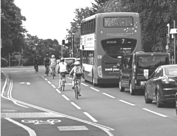
Fig 6: Travelling towards the city centre, the segregated red cycleway on Hills Road merges with motor traffic at the junction with Long Road to the left and Queen Edith’s Way to the right.
The painted lane and bike suggesting travel towards the camera is a lane which existed before the red segregated route was built.
This lane gives access to the hospital at a bike and pedestrian entrance behind the camera and a little way from the roundabout in Fig 5.
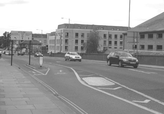
Fig 7: Where Hills Road crosses the railway tracks running into Cambridge station, the cycleway becomes painted rather than raised slightly higher than the motor carriageway.
People on bikes heading towards the city centre take the lane to the right of the yellow bollard, between the motor traffic lane heading in the same direction and a shared lane for traffic turning left onto Brooklands Avenue.
The white sign encourages all users to make sure that they are in the correct lane.
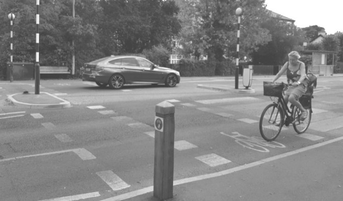
Fig 8: The other major route between the city centre and outlying areas which includes segregated cycleways is Huntingdon Road.
Much like Hills Road, there are parts which are painted and others which are segregated with a raised kerb.
There are also floating bus stops.
The most unique feature of Huntingdon Road compared to Hills Road however is this zebra crossing, which caters for people travelling on foot as well as by bike.
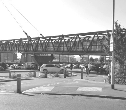
Fig 9: Approaching Cambridge railway station via Devonshire Road, the Tony Carter cycle and pedestrian bridge across the railway and station car park also crosses this cycle and pedestrian only access route to the station.

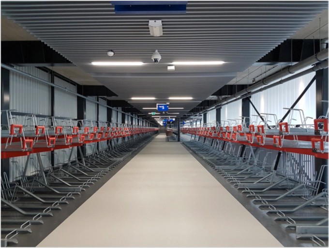
Fig 10: Cambridge station has a large Dutch style cycle park which can hold nearly 3,000 bikes.
Under cover and arranged over three floors, it contains double deck racks such as the above as well as the more traditional (for the UK) hoop stands for cargo bikes and bikes with baskets or child seats.
This image was taken on a Sunday on the first floor. As can be seen it is quite full; however there were more spaces available on the second floor.
The cycle park is behind the Tony Carter Bridge seen in Fig 9.
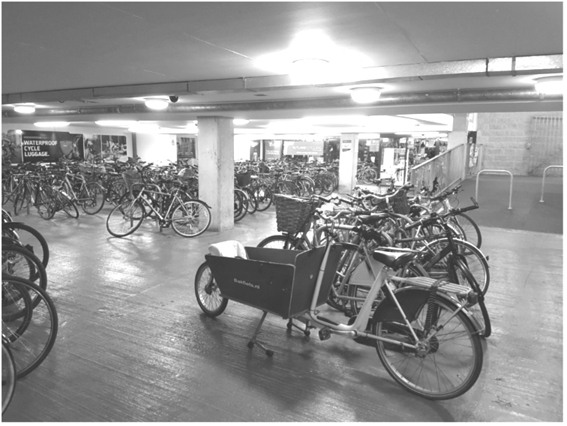
Fig 11: Cambridge city centre is also equipped with some undercover cycle parking. This is the facility under the Grand Arcade Shopping Centre, which is very well used and almost always full.
At the back behind the blue signs is a bike shop for sales, servicing and hire of bikes for visitors.
The same company also has a shop at the cycle park at Cambridge railway station.
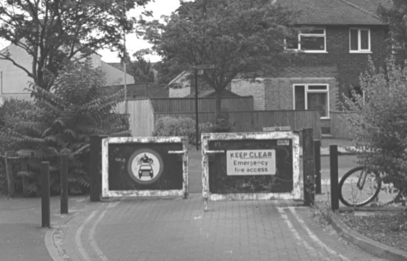
Fig 12: Many side streets in Cambridge, particularly in the neighbourhoods around Mill Road, have gates like these to prevent the streets being used as rat runs by motor vehicles while still allowing bikes to pass through the gap in the middle, and pedestrians to the sides.
This set is at the junction of Rustat Road (behind the camera), Charles Street and Greville Road (to the right).
It is on a popular cycle route between the Cherry Hinton area of the city and the railway station.
The streets in this area are usually very quiet and pleasant places to cycle as a result of this filtering.
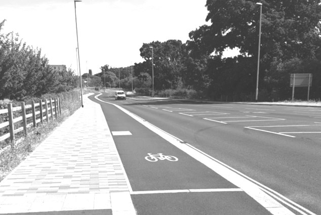
Fig 13: Among the newest residential areas of Cambridge is the Eddington area, part of the University of Cambridge’s North West Cambridge development site.
The road giving access to Eddington from Madingley Road includes segregated cycleways on each side, with more floating bus stops a little further along the road beyond the van.
The lanes however start/finish just behind the camera, with a shared use pavement or the road beckoning for those on bikes heading to the city centre.
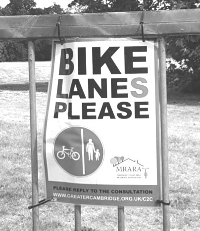
Fig 14: Local residents in the Madingley Road area not far from Eddington are making their feelings known regarding bike lanes segregated from motor traffic.
This highlights the good infrastructure in some areas of Cambridge, but the missing links between those areas.
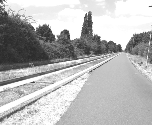
Fig 15: Cycle routes are also starting to radiate out from Cambridge to surrounding towns and villages.
This is the route which runs alongside the Cambridgeshire Guided Busway.
Apart from where it infrequently needs to cross roads on the level via signalled crossings, this wide route stretches 14 miles uninterrupted from Cambridge North railway station to the town of Saint Ives, via Cambridge Science Park (similar business park to Thames Valley Park), Cambridge Regional College, and the villages of Histon, Oakington, Longstanton and Swavesey.
The route was once a railway line.
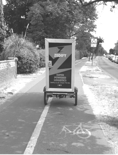
Fig 16: A number of pedal powered delivery firms operate in and around Cambridge, emphasising the normality and acceptance of cycling there, especially as a transport solution for businesses.
I was stuck behind this electrically assisted cargo trike for some distance along Milton Road, however I didn’t mind one bit!
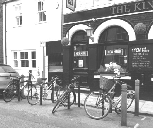
Fig 17: A number of predominantly residential streets, especially in the neighbourhoods of terraced houses around Mill Road, have begun to take back street space from car parking to allow bike parking.
This example is on Kingston Street, where one former car parking space now accommodates hoop stand parking for eight bikes.
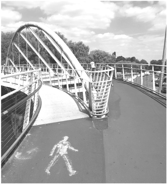
Fig 18: There are a number of pedestrian and cycle only bridges over the River Cam.
The newest and most impressive is the Riverside Bridge seen here, opened in June 2008 and linking the Chesterton area with a supermarket (which partly funded construction).
As can be seen, there are separate pedestrian and bike lanes where the bridge deck crosses the river.
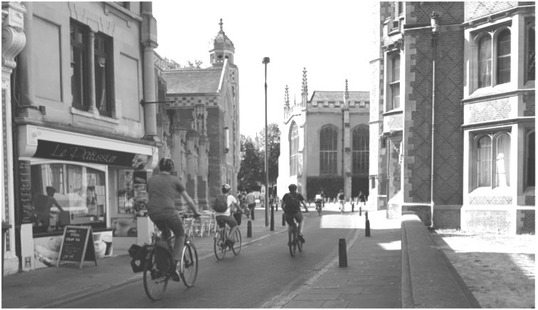
Fig 19: The narrow, predominantly medieval planned streets in the very centre of Cambridge are mostly prohibited to motor traffic, however are very good for cycling.
This is St John’s Street, outside St John’s College on the right.
Routes and infrastructure seen in the previous figures make this cycle friendly core accessible from other areas of the city.
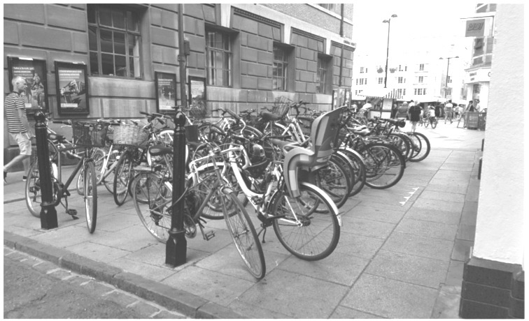
Fig 20: In the centre of Cambridge, there is no escape from bicycles!
This is Guildhall Street, where the road into Market Hill was blocked many years ago and now filled with bike parking.
Cambridge I hope shows what can be achieved for cycling in a UK context perhaps more relatable than the Dutch context of my piece in the last newsletter.
There are missing links in the infrastructure; however these are gradually being filled as design standards are updated.
Of note for the future in Cambridge is the proposed construction of a Dutch style roundabout, where bicycles are fully segregated from and have priority over motor vehicles, which will perhaps be the subject of a future piece.
Harder to export is the more intangible cultural acceptance and normalisation of cycling in Cambridge, born of the city’s history and present circumstances.
However if residents, businesses, the Council and other stakeholders were to share a vision of a Reading where riding a bike is a normal and accepted part of daily life, then we would have a fair shot at achieving it.
Chris Bonham
Chris Bonham, thank you for the informative article about Cambridge cycling infrastructure. Do I feel envious or just frustrated at the lack of imagination and resourcefulness shown by local authorities in our area? Yes, a mix of both. Cycle friendly Reading? ha ha ha. Well done Reading Cycle Campaign for sticking with it all these years, keep on doing it people!